Why Old Roads Keep to the Valley Floor
Why old roads keep to the valley floor becomes clearer when you follow shelves, crossings, and bends—a practical way to read a route without mistaking every hollow for a road.
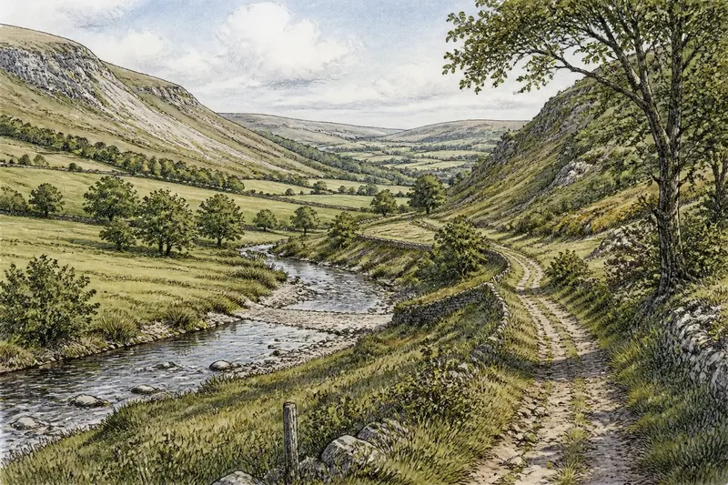
Old roads often keep to a valley floor because the gentlest route is rarely the straightest one. On a valley walk, a level shelf above a stream, a manageable crossing, and a bend around a steep spur can explain an alignment that looks indirect on a map.
Why do old roads follow valley floors?
A valley gathers movement into a narrow band. Ridges and steep side slopes limit comfortable passage, while lower ground offers connected stretches where a traveler can make progress without climbing each shoulder and spur. A route for carts would also have favored gradual grades and firmer surfaces over abrupt slopes or soft ground.
The easiest line is not always beside the water. It may run along a terrace, a slightly raised strip above the stream, or a broad bench at the foot of a slope. These surfaces can offer steadier footing than a wet channel margin while staying close to water. As a valley narrows or opens, a route may move between them.
That terrain gives a road its rhythm: a gradual curve around a hill, a close passage beside a stream, then a higher ledge where the valley tightens. The bends often reflect the available ground more than a desire to connect distant places by the shortest line.
How do crossings influence the route?
A stream provides water but also demands a crossing. Travelers would have had reason to look for a reach with a firm approach and a manageable channel, rather than descend steeply to deep or unstable water. A shallow gravel bed, a narrow stretch, or a gentle bank may make a crossing plausible, though the surface alone cannot establish how or when people crossed there.
A bridge may leave paired approaches, breaks in the banks, or road lines that converge toward a channel. A ford might leave little visible construction. Either way, consider what lies on both sides of the water: an approach that continues in the same general direction is more suggestive than a single hollow that ends at the bank.
A route may travel along one side of a valley before crossing. What looks like a detour on a modern map could reflect firmer ground or a gentler descent at the crossing point. The crossing is part of the route’s shape, not a separate detail.
What clues can you follow on a valley walk?
Start with a sequence rather than a single mark. A shallow hollow might be a worn way, but it could also be drainage or a trace of later land use. A raised strip might be a roadbed, a field boundary, or soil accumulated beside a track. The interpretation becomes more plausible when the line continues, meets a suitable crossing, and fits the contours beyond it.
Vegetation can help reveal a line without dating it. Trees, a change in grass growth, or a narrow band of shrubs may follow a former route or boundary. On sloping ground, a contouring track may look like a level shelf; a more direct path up the hill cuts across the slope. Neither shape alone establishes that a road is old.
Modern changes can imitate or alter these features. A farm lane may reuse an older corridor, a ditch may follow a convenient grade, and a newer road may straighten an earlier route. Compare the line with slope breaks, streams, and possible crossings. Avoid treating any one clue as decisive.
- Observe the ground beside the stream: If a level shelf continues above the wet bank, follow its line visually; if it breaks into steep or boggy ground, look for a higher bench rather than assuming the route ended.
- Check the hollow’s direction: If it continues in a consistent direction toward a pass or crossing, compare it with the next stretch; if it stops abruptly, consider drainage or a recent track instead.
- Look at both approaches to water: If traces on each bank point toward a manageable reach, treat a crossing as plausible; if only one approach is visible, keep the crossing uncertain and look for another route line.
- Compare the line with the slope: If it bends around a steep spur while keeping to a gentler contour, note the contour as a possible reason; if it climbs directly across a steep face, consider a newer footpath or a different purpose.
- Notice nearby vegetation and boundaries: If a tree line or hedge aligns with the hollow, compare its course with the wider valley; if it follows a field edge rather than a continuing corridor, favor a boundary explanation.
- Check the route from an allowed public path: If the line can be followed visually without crossing a boundary, continue comparing it with the land; if access is unclear or the feature lies on private ground, stay on the public route and consult maps or public heritage records.
How can a short walk test a route idea?
Imagine a fictional valley called Alder Run. A walker begins at a broad meadow and notes a faint, level hollow entering between two low hills. The stream lies below the meadow edge, and the hollow follows a raised shelf rather than the wet bank.
The walker then follows the land visually toward a narrow reach. Across the stream, a second level trace begins near a shallow gravel stretch; both traces point toward one another, and the banks offer gentle approaches. The walker records a plausible crossing, not a confirmed one. Farther along, the hollow bends around a steep spur instead of climbing over it, which fits the idea of a route seeking gentler ground.
Before deciding, the walker compares the traces with a field boundary and a drainage line visible nearby. The boundary turns away from the valley corridor, while the hollow continues toward another broad shelf. The resulting interpretation is that an older route may have used the shelf, crossed at the narrow reach, and followed the contour around the spur. Its precise age and purpose remain unresolved.
Which questions help distinguish a road from a landform?
Does a hollow in a valley mean an old road?
No. Drainage, livestock, and later land use can all leave hollows, so check whether the line continues and fits nearby slopes and crossings.
Why would a road stay above the stream?
A terrace or shelf may be drier and more stable than the immediate bank while remaining near water. The route can descend where a crossing has a manageable approach.
Can a modern lane preserve an older route?
It can, particularly where the valley offers few comfortable corridors. But a lane may also be newer or altered, so its alignment is a clue, not a date.
What makes a route line more persuasive?
A sequence of compatible features matters more than an isolated mark: a level shelf, a plausible crossing, and a continuing line beyond it. The interpretation should fit the surrounding terrain without requiring an implausible detour.
What is not worth the effort?
It is not useful to force every bend into one explanation or call every depression an old road because it points toward water. Farm use and drainage can produce convincing false leads. A restrained reading—this line may follow an older corridor—is often more credible than assigning a precise route or purpose from surface clues alone.
Stay on public paths and respect boundaries. If access is unclear, observe from an allowed route; maps, aerial imagery, and public heritage records can help you compare a feature with known lanes and crossings.
On a valley walk, the question of why old roads keep to the valley floor is best answered by watching how the land connects: shelf to crossing, crossing to gentler slope, slope to the next level stretch. Even when the road surface has disappeared, that sequence can show why a traveler might have chosen one corridor over another.